Hike around the Colomers cirque

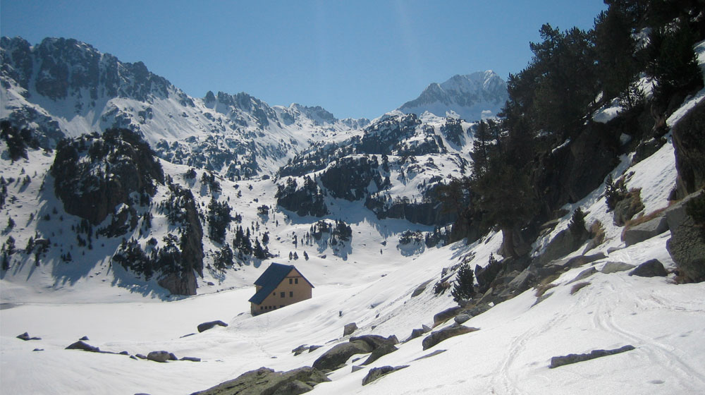
Circ de Colomèrs | Estanhs de Colomèrs

Technical data

Diffficulty: Easy

Technical difficulty:S2

Modality: Snowshoes

Longitude: 5,5 km

Time: 2h

Elevation: +200

Class avalanche terrain: Simple

Description

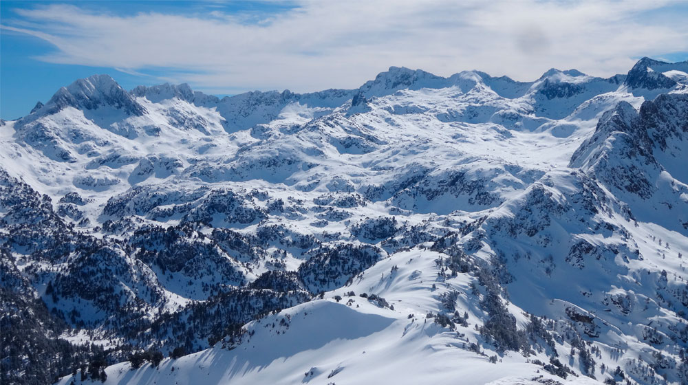
In addition to the popular short and long itineraries around the Colomers cirque, we’d like to propose this “intermediate” route in terms of distance and height difference to cover. The route will take you round many lakes and up close to the imposing peaks that surround the cirque. While the technical difficulty of the hike is low and the ground is even, we recommend doing this route in good weather and visibility to find your way better and admire the spectacular scenery.

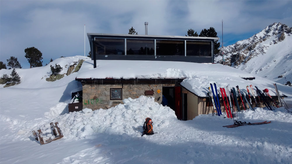
If you’ve spent the night at the mountain shelter, you’ll need to go back to the old shelter and cross the dam. Head in this direction to reach the Coret deth Clòto. Don’t go down to the Clòto lakes you’ll see ahead, but instead walk south towards the Estanh Long. Continue up the valley, past the Estanh Redon and towards the more prominent Estanh Obago, with the stunning face and northwest slope of Tuc de Ratèra as a backdrop. Approximately halfway along the shore, where there’s a small peninsula, turn westwards to follow a small valley that leads to a plateau with Estanhs des Gargolhes and Estanh des Cabos in the foreground. Carry on westwards, with gentle ups and downs, past the small Lake Plan and then Garguilhs de Jos up to Estanh Mòrt. From here, take the path coming from Coma deth Pòrt de Caldes northwards and in no time you’ll be back at the Colomers Mountain Shelter.

Carlac Forest

Carlac Forest

Technical data

Diffficulty: Easy

Technical difficulty:S1

Modality: Snowshoes

Longitude: 5 km

Time: 2h

Elevation: +275

Class avalanche terrain: Simple

Description

In the far northwest corner of the Val d’Aran, literally clinging onto a sunny hillside is the quaint little village of Bausen, better known in more recent times as being the setting for the ‘Lovers of Bausen’ tale. Although standing at just 900 m and with a sunny orientation, when the heaviest winter snowfalls come, Bausen and its mountain quickly build up a snowpack. If you’re lucky enough to be out on a cloudless day after a decent snowfall, you can do the classic Carlac Forest route with snowshoes.

From the car park, climb to the top of the village and take the path that heads east towards the San Roque chapel. Take a short detour to visit to the village cemetery, the scene of the legend, and admire the beautiful views of Lower Aran that can be seen from this point. At San Roque, go back on the path signalled with red and white GR markings of GR leaving that stretches out northeasterly above the hamlet of Pontaut and the main valley of the Garonne. The path heads into the beautiful beech forest and starts to rise progressively, now in a northwesterly direction. As we move towards the north-facing slope, the trees become increasingly taller, older, more twisted and more spectacular. Cross the Carlac ravine over a wooden walkway and then the path takes a sharp turn to cross the same ravine again. Continue along the path, now southwards, until you suddenly come out of the woods at a place called Coret Pan, the highest point of the itinerary. Bausen is down below, but you still won’t be able to see it. You’ll start heading downhill through meadows until you come across the first shepherd’s huts. The path continues to loop its way down until reaching the upper part of the village.

Tuc de Betlan

Tuc de Betlan | Es Cobos

Technical data

Diffficulty: Moderate

Technical difficulty:BE-S3

Modality: Ski mountaineering

Longitude: 13 km

Ascent time 4h and descent 2h

Elevation: +1135

Clase terreno de aludes: Demanding

Description

At the northernmost tip of the Val d’Aran, the Toran valley is without any doubt the wildest of all. Although the altitude of its peaks is modest and the elevation of its main entrance – the Dera Honeria Mountain Shelter (1008 m) – is fairly low, its markedly north-facing position means you can ski down from the shelter in midwinter. However, you’ll need to approach along the track and using the forest harnesses. Leaving the forest, you’ll see a surprisingly alpine and unspoilt terrain. The Tuc de Betlan is the most doable uphill ski within the adventure of exploring Torán in the winter.

From the Dera Honeria Mountain Shelter, take the GR-211-3 path along the right bank of Gotèr de Comatroja. This way you’ll avoid the initial indirect course of the track. You’ll end up on it again at 1100 m after crossing Gotèrs de Bredreda, Comatroja and Arbaet, then continue about 2 km to the altitude of 1361 m, where you’ll find a clearly-marked trail that climbs steeply to the left. Go onto it and zigzag your way through the forest. It’s easy to miss this stretch, as the path is becoming less and less apparent. As a reference, you’ll need to come out at the lower clearing in the forest (altitude 1700 m) from the place called Es Cobos. Keep walking southbound and then you’ll reach Cobos, a pretty cirque bordered on the west by the Sèrra de Peirahita and on the sloping north face by Tuc de Betlan itself. Without there being an obvious route, look for the best way to reach the Serra de Peirahita while paying attention to the snowdrifts and cornices that are often formed there. Now don’t leave the ridge that gets wider and wider towards the peak. You should also take care on the steeper section of the western slope of the Serra de Peirahita, as it’s easy to have a serious fall here. The Tuc de Betlan is a sweeping expanse at the peak, contrasting with the complex terrain surrounding it in all directions. Its position further north than the rest of the mountains in the shadow of Torán makes it an excellent vantage point. If Tuc de Betlan is your first winter excursion, then head back down to the car along the same route.

Access to the Saboredo Mountain Shelter

Refugi de Saboredo | Val de Ruda

Technical data

Diffficulty: Moderate

Technical difficulty:ME-S2

Modality: Snowshoeing and skiing

Longitude: 9 km

Time: 3h – 4h

Elevation: +800

Clase terreno de aludes: Demanding

Description

The Saboredo Mountain Shelter provides access to the U-shaped Saboredo cirque, at the head of the Ruda valley. Like the route to Colomers through the Aiguamòg valley, access to Saboredo through the Rusa valley, without being technically complicated, is a long-distance excursion that passes through the valley, with some sections prone to possible avalanches that will require attention. Scenery-wise, heading into the Ruda valley with snow-capped mountains is truly stunning, and if you can spend the night at the shelter (bookings available from early February), you’ll have time the next day to climb one of the peaks forming the cirque or one of the hills that link Saboredo with the neighbouring sectors of Colomers, Amitges or Gerber, all within or bordering the National Park of Aigüestortes i Estany de Sant Maurici.

Once past the Baqueira resort, head down to the Ruda valley floor. You can generally arrive by car to the access track to Pontet Ruda. Cross the Pontet pass and start heading up the Ruda valley on the track on the shaded side. Along the 4 km to Locampo bridge, you’ll be exposed to the Palas de Ruda, which in the event of heavy snowfall or prolonged melting may trigger avalanches. Cross on to the right bank of the river at the Locampo bridge and keep going up the valley. Now you’ll be exposed to the west-facing avalanche paths descending from the Tres Picos sector. These are also dangerous during or shortly after major snowfall or prolonged melting, affecting the track and right down to the river.

The track heads into the forest and, after winding around somewhat, ends right next to the hydroelectric facilities. Follow the summer path, first crossing over a rocky bar, to the Pleta Saboredo. Climb over a second rocky bar on the left side and then you’ll get to gentler terrain leading to the shelter.

Access to the Restanca Mountain Shelter

Refugi dera Restanca | Pontet de Rius

Technical data

Diffficulty: Moderate

Technical difficulty:ME-S2

Modality: Snowshoeing and skiing

Longitude: 4 km

Ascent time 3h and descent 2h

Elevation: +600

Class avalanche terrain: Demanding

Description

From Artiés, take the Valarties track and – depending on conditions (check reports on forest tracks) – drive up to the car park at the Ressèc bridge, located 9 km from Artiés.
After leaving the car, follow the track down the valley to Pontet de Rius. After crossing the track to Loseron and Pontet de Rius, this part of the route is prone to avalanches coming down through the northwest-facing channels from the top of Montardo, a thousand metres higher. These are commonplace after heavy snowfall or prolonged melting.

From Pontet de Rius, the safest route is to climb the GR-11 summer path that starts out from the side of the cabin. Head up through the forest, always keeping on the left bank of the River Restanca. On leaving the forest, you’ll see the dam and all that remains is to cross it to reach the mountain shelter.

Access via the “pala Messilla”, on the right bank of the River Restanca, is highly prone to avalanches, also from the top of the Montardo, due to heavy snowfall or prolonged melting, especially from midday on. We therefore recommend this route only as a downhill option on skis and if you’re sure that the snow is stable when passing. If you’re using snowshoes or hiking boots, it’s better to go down the same way as you went up.

Access to the Colomers Mountain Shelter

Refugi de Colomèrs | Banhs de Tredòs

Technical data

Diffficulty: Easy

Technical difficulty:ME-S2

Modality: Snowshoeing and skiing

Longitude: 8,5 km

Time: 3h

Elevation: +690

Class avalanche terrain: Simple

Description

Colomers, located at the top of the Aiguamòg valley and the southernmost tip of the Val d’Aran, is home to the most important concentration of lakes in the Pyrenees. In summer, it’s one of the most popular hiking destinations. In winter, the presence of snow in the valley makes access rather difficult. So, we’d suggest a two-day trip with a night at the new Colomers Mountain Shelter, semi-accessible from December to February and thereafter open until spring. From the shelter, the possibilities are numerous, such lakeside walks or a range of climbs of varying difficulty. The important mountain passes of Puerto de Caldes, Colomers, Ratera and Còth de Sendrosa connect this shelter with other shelters in the National Park of Aigüestortes i Estany de Sant Maurici.

During the winter, the access road to Banhs de Tredós remains closed at the Bòrda de Montadí. From the car park, follow the track towards Banhs de Tredós to avoid making a detour before the forest. From Banhs (when the snowline has risen in springtime, access by car reopens to here), keep on the track that passes beneath the attractive channels of Tuc de Sendrosa. These channels can be dangerous and should be avoided after heavy snowfall or prolonged melting by warmer temperatures or rain, when avalanches often end up cutting off the track. Cross the Arriu d’Aiguamòg through the Pònt la Montanheta and either stay on the track or take another shortcut. At the sign for the Colomers Mountain Shelter (altitude 1975 m), leave the track to follow the summer path that meanders along the right bank of the ravine up to Estanh dera Lossa. Cross the wooden bridge and keep going up the ravine. After a short while, you’ll reach the inlet of the Estanh Major de Colomers lake. Cross it to access the old Colomers Mountain Shelter, from where you’ll be able to see the new shelter. Walk around the lake and your destination will be in front of you.

Tuc d'Aubàs

Tuc d’Aubàs | Còth de Baretja

Technical data

Diffficulty: Easy

Technical difficulty:ME-S2

Modality: Snowshoeing and skiing

Longitude: 11 km

Ascent time 3h and descent 2h

Elevation: +800

Class avalanche terrain: Simple

Description

Away from the more crowded and popular sectors of Upper and Middle Aran, from the border crossing of Portilhon in Lower Aran we can access a mountainous sector with a marked climate and Atlantic landscape. In midwinter, there’s always a good snowpack on a grassy and not so rough terrain, ideal for novices to the mountain in winter. On leaving the forest and reaching the crest, you’ll be greeted by stunning views over the Vallée de la Pique in France and Mount Aneto, with Mount Maladeta looming in the background.

Park at the start of the track leading to Còth de Baretja, or in Portilhon itself if there’s too much snow, and walk for a few metres along the road until you see the track. If you don’t want to complicate the itinerary, always stick to the track up to the Cap deth Bosc cabin. If the snow is thick enough to cover shrubs and trunks, and you want to avoid covering too much distance, at the bend adjacent to the Plan des Bruishes you can go off the track and southwards through the forest. You’ll come out at the final part of the track just before the Cap deth Bosc cabin. From here, you’ll continue off-track along the central part of the broad valley up to Còth de Baretja, which has two cabins, one on the Aranese side and the other on the French side. Turn east and climb the uncomplicated 300 metres of the gentle summit up to Tuc d’Aubàs itself. The return will be the same route uphill.

Apartments FeelFree | Holidays start here

At FeelFree we manage quality apartments and holiday rentals in different destinations. Our service is based on the network of professionals who reside in the destinations that we offer, which allows us to give a personalized attention.
The apartments and holiday homes managed by FeelFree have been selected on-site based on strict criteria of quality, design, location and equipment. Our main goal is therefore that our clients can feel at home during their holidays or business trips.
We offer a large selection of apartments, villas and holiday homes. Contact us and we will help you in choosing the apartment or villa that best suits your needs.
Our experiences in the real estate and tourism sectors have given us a lot of information, which serves as a core to set the FeelFree philosophy based on quality and simplicity.
To manage the quality we select apartments based on their optimal location and authentic decoration.
To get closer to simplicity we have designed an apartment reservation system that allows you to make an online reservation in the easiest way.

Aran Mountain

Empresa de Guías de Montaña y Nieve de la Val d’Aran. En invierno se organizan diferentes actividades como: rutas con raquetes de nieve, esquí alpino, esquí de fondo o snowboard. El resto del año, se puede hacer senderismo por múltiples parajes: por las riberas de los ríos, lagos, cascadas y por los diferentes pueblos de la Val d’Aran, que esconden grandes vistas y visitas. Además de hacer rutas a pie también se pueden hacer rutas en BTT.