Tour around Pontet

Pontet 

Technical data

Diffficulty: Easy

Technical difficulty:S2

Modality: Snowshoes

Longitude: 7 km

Time: 3h

Elevation: +600

Class avalanche terrain: Demanding

Description

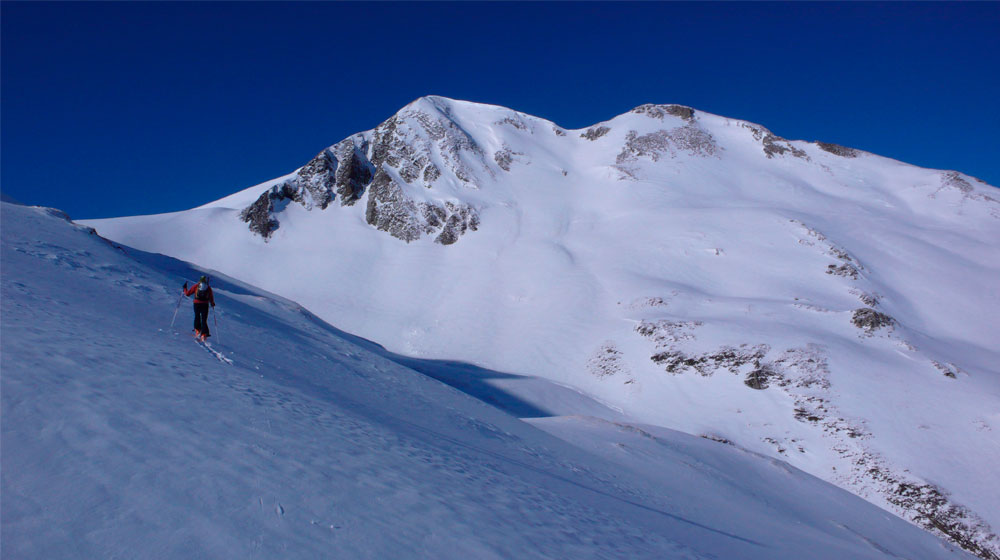
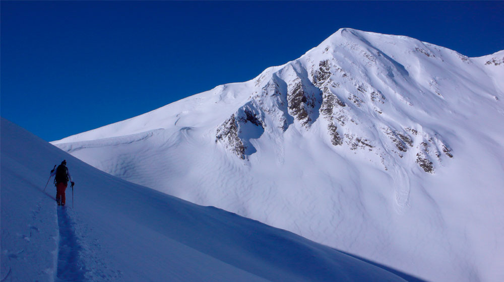
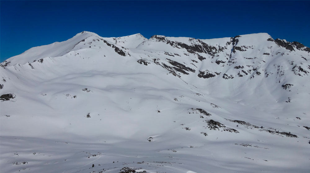
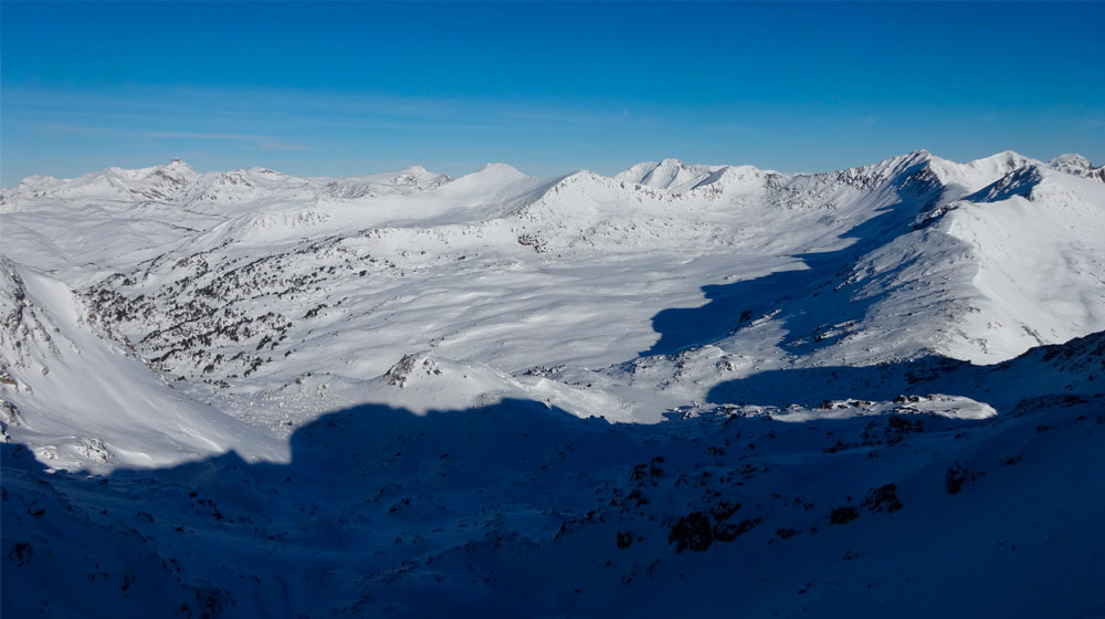
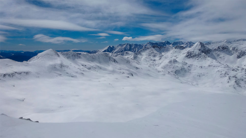
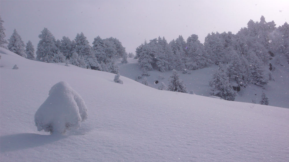
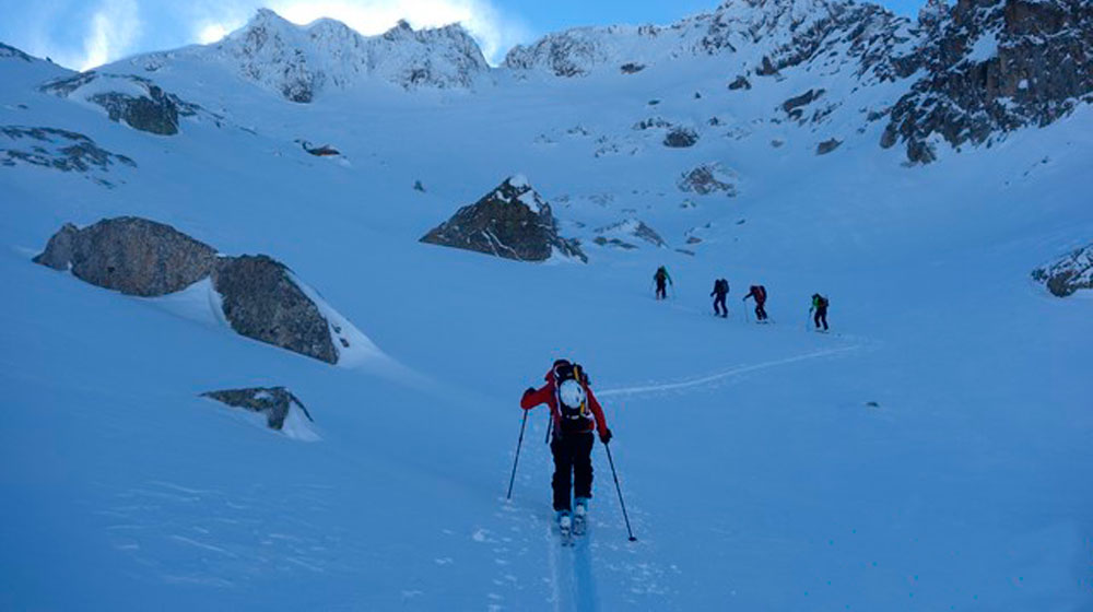
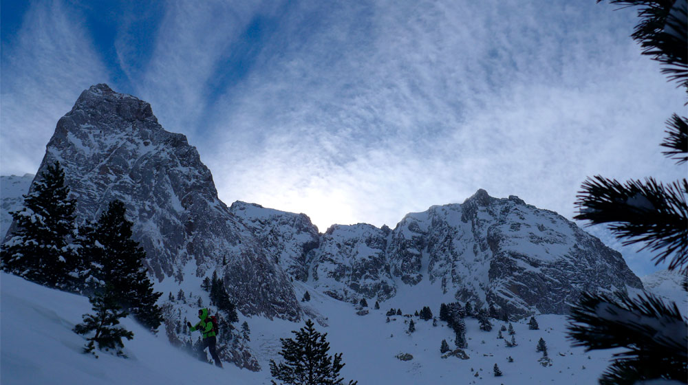
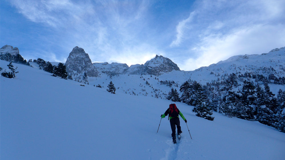
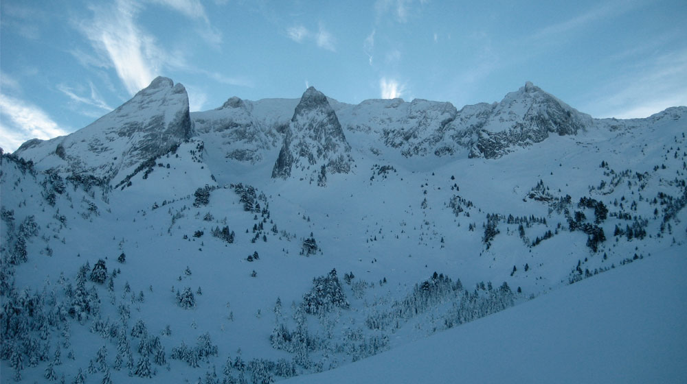
In deepest midwinter, when the snow is deep and especially after a good snowfall, we propose this snowshoe excursion starting from the northern mouth of the tunnel right into the Pontet sector. After crossing the fir forest, the route will unveil the Sierra de Fontfreda as a backdrop and a glacial landscape formed by moraines, small basins and cirques, and sharp spires. You’ll enjoy a safe and privileged route to the foot of Tuc des Hemnes, which without question is one of the most beautiful snapshots of the Val d’Aran.

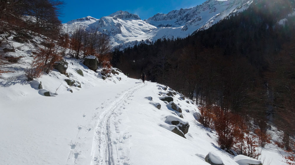
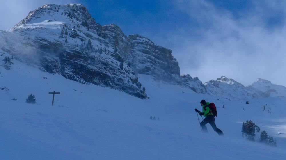
From the car park of the north mouth to the tunnel, almost always blessed with continuous snow, follow the north-facing track that gently flattens out until you come across the summer path towards Pòrt de Vielha. Cross the fir forest following the path or zigzagging through the wider clearing until coming out at the Deth Pontet shepherd’s hut. Continue the gentle walk along the right bank of the river to Pontet and the red iron cross. Cross the ravine, and instead of following the summer path that goes up the moraine, continue along the valley floor, gradually gaining altitude. When the ground begins to get steeper, turn eastwards onto another easy-to-find moraine. Keep on climbing southwards through the moraine and, among scattered pine trees and a small stretch of steeper slope, you’ll reach the altitude of 2000 m. Suddenly you’ll find yourself in front of the imposing Tuc des Hemnes and the cirque formed by the Tuc and the Pala de Sarrahèra. You can head back down along the same route or by taking the northwest-facing valley that descends directly to the River Fontfreda. Here you’ll find the original uphill route that will take you back to the starting point.

Tuc dera Pincèla

Tuc dera Pincèla | Era Ribèra

Technical data

Diffficulty: Moderate

Technical difficulty:BE-S3

Modality: Ski mountaineering

Longitude: 12 km

Ascent time 3h30 and descent 1h30

Elevation: +1115

Class avalanche terrain: Demanding

Description

The Tuc dera Brush, despite its modest altitude, dominates the northern valleys of the Val d’Aran. Located between the banks of the Unhola, the Varradòs and the Salient, from atop you’ll be able to admire the hills bordering France, to the north, and the entire ridge dividing the Pyrenees, to the south. The climb is along smooth and grassy terrain, ​​very different from the granitic soil to the south, and offers spacious and gentle slopes, perfect for times in the season when snow is scarce.

When there’s snow on the valley floor, you can start off from the village of Bagergue, or if the track is clear, you can save yourself a long flat stretch to La Bòrda from Peró. From here, the safest option to climb up to the Plan de Moredo is by following the summer path on the south-facing side and crossing the Moredo ravine at the highest and least sandwiched-in portion. If the snow is scarce on the south-facing sides and also stable, cross the Moredo ravine beside Bòrda and gain height across the open meadows, without any detours along the track, first to the west and then to the northwest. There’ll also be the odd stream to cross. Then you’ll come across the track again and continue towards Plan de Moredo. Take care, though, because this is a stretch prone to wet avalanches and frequent landslides that descend from the Pala de Hèr. Before reaching the Plan de Moredo, you can leave the track to enter the Coma d’Arenho. Avoid the deep bed of the ravine and gradually zigzag your way along the slopes on your left up to some plains where the valley is divided into two. To the right, leave behind a smaller valley and look for the high ridge on the right-hand bank of the ravine in the main valley, keeping away from the northeast-facing slopes where unstable rock formations are commonplace. Stay on this ridge until just before heading out to the majestic Colhada des Clòts de Monnàs, where you’ll have to take a less exposed flank to reach the mountain pass. From here, the route goes south. To reach the top, climb up towards the wide pass between Tuc dera Pincèla and Tuc d’Arenho, avoiding the south slope and walking the final few metres along the wide and comfortable ridge. The safest descent is along the same route. If the south-facing snow is very stable, you can choose to descend from the summit along the south slope directly to Colhada south and from this point to continue the descent following the uphill stretch.

Tuc de Parros

Tuc de Parros | Vall de Parros i Clòsos

Technical data

Diffficulty: Difficult

Technical difficulty:BE-S3

Modality: Ski mountaineering

Longitude: 14 km

Time: 5-6h

Elevation: +1150

Class avalanche terrain: Complex

Description

Tuc de Parros, thanks to its easy access, fairly level grassy terrain, and shallow ski-friendly snow, is one of the most popular climbs in the Val d’Aran. Here we propose a circular route, up the barren Parros valley, passing by the Estanh Nere and climbing the SW point, about 300 metres from the actual summit, which can be reached on skis or on foot following the crest. To avoid too much pole work, you should head back down via Cap des Clòsos and directly to Pla de Beret.

From the Pla de Beret car park, head downhill for around 2.5 km on the trail beside the Noguera Pallaresa on its left bank towards Montgarri, until finally reaching the Parros shepherd’s hut. From the hut, you can begin the ascent through the eponymous valley. First on the left bank of the river, and then on the north-facing side when the valley narrows. Avoid following the course of the river, as small-scale avalanches can occur here. When the valley opens out (altitude 2100 m), follow the central part while taking advantage of small protrusions that allow you to gain altitude quickly. The hill will be at the end of the valley floor and directly ahead will be the rocky ridge that descends from the summit and splits into a pass halfway up. Take the path to this pass, avoiding the SE approach to the slope of Sèrra dera Mòrto, where there are often unstable rocks or the risk of wet snow avalanches triggered by heat or sunlight. From the pass, cross the NE side of the valley to the top. Keep going up along the increasingly soft ground, leaving the basin with the Estanh Nere Parros down to your right, and avoiding snow drifts which may have formed near the ridge line. Once at the summit, you’ll enjoy a magnificent panoramic view with the imposing silhouette of Tuc de Mauberme towards the north.

If unsure about the stability of the snow, start the descent following the same route. If stability on the NE stretch is good, then you can leave the pass behind to the right and continue down the valley to the plain where there’s a snow cover probe. From this point or from above, if you’ve come down to the valley following the outgoing route, then go back to Cap des Clòsos around its NW side. From the summit go slightly downhill, but without going into the Barlongueta valley, to link up with the crest line of Tuc deth Miei. Then go up to the summit and descend directly to the Beret car park, avoiding the steeper valleys where sometimes there are unstable snow drifts.

Montlude

Montlude | Uishèra

Technical data

Diffficulty: Difficult

Technical difficulty:BE-S3

Modality: Ski mountaineering

Longitude: 19 km

Ascent time 5h and descent 2h

Elevation: +1530

Class avalanche terrain: Demanding

Description

In the northern sector of the Val d’Aran, nestling among the Toran valleys to the north, the Garonne to the west, and Varradòs to the south and east, are two majestic mountains visible from many parts of the entire region: Montanha d’Uishera and Montlude. Reaching the peak from the village of Arres is a long and demanding day of skiing, which we recommend doing with packed snow and especially on south-facing sides. All the effort will be paid off with spectacular views over the mountains dividing the Val d’Aran from the southern Pyrenees, Mounts Aneto and Maladeta, and the 3000-metre-plus peaks of Luchon.

From Arres de Sos, you can normally go by car on the initially paved track towards Bassa d’Arres, up to the curve where the village oil tank is found. Start climbing up northwards over the gently-sloping open meadows until reaching the track that by now has split into two. Take it towards the east, which climbs up through red pine forest, and after two sharp turns you’ll find a small stone hut on the left (1725 m elevation). Walk up this clearing for 50 metres in a northeasterly direction until you see a path that climbs diagonally. Turn onto it and continue in a southeasterly direction. Depending on how thick the snow is, you might find it tricky to see this path, as it’s quite hidden due to its disuse. For reference, you should come out on the wide curve at 1875 m on the same track that you left behind previously. Take the track again and keep going until the Plan d’Uishera, with the shepherd’s hut. From here, you can clearly see the rift to the north that you have to reach, standing among the peaks of Montanha d’Uishera and Tuc de Sacauva. Once on the rift, head for Tuc de Sacauva and continue along the ridge in a northeasterly direction to Penha Blanca (2287 m). From here, there’s a slight drop of a few metres along the northern ridge (left-hand), so go down the small valley (northeast-facing) which isn’t as steep as the rocky bar below Penha Blanca. Then you’ll reach Horats de Margalida. Then head up the gentler slopes to the left of the ravine up to Estanh Long de Vilamós. Now it’s time for an uphill flank, following the same northeast course, to find the pass that will lead to Lake Redon, and shortly afterwards, a supply reservoir. Keep going up in the same direction until the east ridge of Montlude and then turn west to climb the Còth der Estanh. This is a short but very steep stretch that sometimes has large snowdrifts. Alternatively, you can go around the mountain and head up from the north face, normally much more barren and frozen over. From the pass, continue along the relatively straightforward broad ridge to the summit. The descent is best along the same route, with the option of taking the crest from Estanh Long de Vilamós and staying on it to Tuc de Sacauva and the rift on the side, which will let you descend to Plan d’Uishera.

Montgarri

Montgarri | Cabau

Technical data

Diffficulty: Easy

Technical difficulty:S1

Modality: Snowshoes

Longitude: 10 km

Time: 3h

Elevation: +200

Class avalanche terrain: Simple

Description

The old village of Montgarri is located beyond the Pla de Beret, downstream from the border of Noguera Pallaresa and next to Pallars Sobirà. Poor traffic links triggered the depopulation of the village in the mid-twentieth century and the progressive abandonment of the sanctuary, rectory and hospital. At the beginning of this century, with the restoration of the sanctuary and the refurbishment of the Mountain Shelter, Montgarri has come back to life and is now an idyllic must-visit. In winter, with the snow-covered landscapes, a low-difficulty snowshoe excursion is a magical journey to enjoy with family and friends.

From the Pla de Beret, the itinerary proposed here follows the track that runs along the left bank of the Noguera Pallaresa, usually with continuous hard-packed snow right up to the Sanctuary. The downhill section is progressive, pleasant and varied, with more open areas to admire the snow-covered mountains and more sheltered stretches with black pine forest. You’ll cross the River Parros, where there’s a shepherd’s hut, and the River Horcalh by the Can Cabau house. After 1 km you’ll catch the first sight of the sanctuary. All that remains is a gentle walk to your destination. Must-visits include the Romanesque sanctuary and the Amics de Montgarri Mountain Shelter, where you’ll find a bar and restaurant. If you’re interested, the abandoned village is located less than 1 km from the sanctuary, down the trail that now runs along the right-hand bank. To return, it’s better to take the same route, as this trail is exclusively for users with snowshoes and skis, while the trail that runs along the right-hand bank is much more popular with dog sleighs and snowmobiles.

Montardo

Montardo | Restanca

Technical data

Diffficulty: Moderate

Technical difficulty:BE-S3

Modality: Ski mountaineering

Longitude: 6,5 km

Ascent time 3h and descent 1h30

Elevation: +830

Class avalanche terrain: Complex

Description

Probably the most classic climb in the Val d’Aran, the Montardo is a varied itinerary that includes forests at the bottom, frozen lakes during the ascent and a slender slope at the peak. The view from the top is unbeatable, with the Val d’Aran extending northward and the National Park of Aigüestortes i Estany de Sant Maurici to the south. The climb can be done in one (long) day from the Pont de Ressèc or split into two days, spending the night at the Restanca Mountain Shelter. The various downhill options, depending on your level of skiing and stability of the snow, perfectly round off a climb that lives up to the popularity of the mountain. Here we’ll review the ascent from the Restanca Mountain Shelter. Access to the shelter is covered in a separate info sheet.

From the Restanca Mountain Shelter, take the Estanh deth Cap deth Pòrt valley. It’s best to take the flatter ground near the dammed lake to the lower part of the valley to avoid the landslide-prone terrain to your left. Head up the valley, paying attention to the possibly unstable rocks on both sides of the ravine. From the lake, you’ll see the imposing Coret de l’Oelhacrestada in the background. From here, the route is prone to avalanches that crash down from the southern slope of the Agulhes deth Montardo to Oelhacrestada. It’s best to follow the valley in the middle, as you also have to watch out for unstable rocks on the shaded side. It’s often very windy in the last few metres before the hill. Once you’ve gone past Oelhacrestada, head up the south-facing slopes to Còth deth Montardo. In this area, the snow quickly changes and it’s difficult to choose a safe route. Once at the Còth deth Montardo, all that remains is the final east-facing slope. This is complex terrain, prone to unstable rocks, which may sometimes force you to give up the ascent to the summit. The safest option is to reach the top on the left-hand ridge.

You can go down the same route or, if you have a good level of skiing, knowledge of terrain and the ability to assess the stability of the snow, you can consider heading down the popular “hidden” channel and the north face or continuing on the northeast face and descend towards Lake Saslòses.

Tuc de Lluçà

Tuc de Lluçà | Colomèrs

Technical data

Diffficulty: Moderate

Technical difficulty:BE-S3

Modality: Ski mountaineering

Longitude: 6 km

Ascent time 2h and descent 1h

Elevation: +1040

Class avalanche terrain: Demanding

Description

Among the many possible climbs from Colomers Mountain Shelter, the nearby Tuc de Lluçà is the ideal choice if you don’t have too much time. The itinerary is initially shared with the popular route through the Port de Caldes towards the Ventosa i Calvell Mountain Shelter, but then veers south and heads for a side valley. The last northwest-facing slope, without being complex terrain, requires care when walking. Atop the summit, you’ll have a bird’s eye view of the spectacular Colomers cirque and the mountains of the National Park of Aigüestortes i Estany de Sant Maurici.

Heading up from the mountain shelter near Lake Mayor de Colomers, the trees give way to rocks and meadows, dotted with lakes and mounds. Look for the Coma deth Pòrt de Caldes, the more apparent valley that opens out to the right (west) of Estanh Mòrt. Here you’ll be exposed to steep and sunny slopes, where there may be avalanches, especially on warm days or in the event of strong sunlight. Further up, the valley becomes narrower and you should look out for possible snow drifts on the shaded sides. At this point, when the slope becomes steeper, if you keep on going uphill, the valley will take you to Port de Caldes. This is a common mistake, especially on days with low visibility. On arriving at the altitude of 2250 m, turn south to go up the small valley that leads to the foot of the slope leading to the summit. This is a very dark area, high up in the mountains and prone to the formation of plaques that can remain unstable for quite some time. It’s best to head up diagonally and towards the east, seeking out the gentlest slope on a relatively smooth ridge until reaching the summit. The descent down the same uphill route is the most common and safest option, as you already know the conditions.

Route around the lakes of Bacivèr

Estanhs de Baciver

Technical data

Diffficulty: Moderate

Technical difficulty:ME-S2

Modality: Snowshoeing and skiing

Longitude: 10 km

Time: 4h

Elevation: +500

Class avalanche terrain: Simple

Description

This circular route passes by all the lakes in the Bacivèr cirque and is ideal for snowshoeing or off-piste skiing. It’s an alternative to the popular Tuc of Vacivèr if you’re after an easier trip, in terms of both technical difficulty and physical requirements. It’s also more doable when the weather conditions and high-level snow cover are not favourable.

From the car park in Orri, take the Arriu Malo valley, between Cabo de Baqueira and Tuc de Vacivèr. You’ll reach a flatter area without forest, and then keep on looking for clearings among the pine trees, staying close to the valley floor to the right of the river. At a relatively close distance you’ll make out the dam wall of Lake Baix de Bacivèr. Keep going through this section (a narrow pass) until reaching the lake, where the spectacular Baciver cirque opens out before you. From here, continue eastwards among scattered pine trees towards the right of a small mountain (elevation 2345 m on the map), and then in a northeast direction until you get to the first of the Dalt de Bacivèr lakes. Depending on the time, the conditions and your inclination, you can walk around the first of the lakes or both of them until coming back to the water outlet of the first lake. From this point, start heading back down the ravine to retrace your uphill route to the shore of Lake Baix. From here, you can keep going down on the same outward route or head in a northwesterly direction to find a descent down a small side valley. Shortly before reaching the car park, you’ll have joined up with the uphill route again.

Tuc des Estanhets

Tuc des Estanhets | Conangles

Technical data

Diffficulty: Difficult

Technical difficulty:MBE-S3

Modality: Ski mountaineering

Longitude: 10,5 km

Ascent time 4h and descent 2h

Elevation: +1400

Class avalanche terrain: Complex

Description

Conangles valley is a prime example of the sweeping terrain of the Val d’Aran. From the valley floor, looking at the north-facing side, there’s a height difference of over 1000 metres, snow and ice channels, and sharp ridges that close the cirque from Tuc de Contesa to Port de Rius. The granite substrate and its location on the southern edge of the valley, more exposed to the effects of wind, don’t make it the most ideal valley to visit in early winter. However, when the snow is thick enough, the south-facing position and the relatively high and convenient access from the southern mouth of the tunnel make it an area where you can keep on skiing well into late spring. Here we suggest heading up the valley to the Collado de Conangles, where you can cross the source of the Ribèra de Rius to climb Tuc des Estanhets, a privileged vantage point overlooking the Rius, Conangles and Besiberri valleys. It’s a demanding route, both physically and technically, that runs through complex terrain.

From the Hospital de Vielha car park, at the southern mouth of the tunnel, set off eastbound and gradually gain ground over the meadows until you find the more winidng track that also comes from the Hospital. Follow it until you get to the confluence of the River Conangles with the Estanh Redon ravine. Here you have two options: in the depths of winter, it’s better to cross the Redon ravine and continue on the south-facing side of the valley, following the GR-11 path. In spring, when there’s little snow cover on the south-facing side, cross the River Conangles over the concrete ford and follow the track that climbs up the north-facing side to the beech forest. In any case, keep as close as possible to the valley floor until reaching the bottom of the cirque. Here you’ll head though the valley of the Conangles ravine, which is well-sheltered from the Contesa channels. The first part is more demanding, but then it turns into a gentler grass-covered slope. At the top of this slope, go back into the ravine valley and keep climbing until you reach the frontal moraine which borders the basin of Estanhons de Conangles. From here you’ll already see the hill, but you’ll still have to overcome a series of steep south- and west-facing slopes, avoiding the narrow channel that runs down straight from the hill. Then you’ll arrive at Còth de Conangles, located between Tuc de Conangles and Tuc des Estanhets, with views of the side of Rius. You’ll have to remove the ski skins to descend the 70-100 m of height difference required to safely pass through the small valley on the north face of Tuc des Estanhets. Head up this small but increasingly steeper valley to reach the marked rift to the left of the summit. The last few metres below the rift are very steep and often have large and unstable snow drifts. If you’re not sure about the stability of the snow at this point, simply turn back. In a very alpine environment, pass through the rift on the Besiberri valley side and you’ll be just a 20-metre climb away from the summit. After deservedly enjoying the spectacular panoramic view, start the descent following the same route. Any variant you may want to take from this route will involve greater exposure, so you have to be very sure of the conditions and stability of the snow before making a decision. From the Còth de Conangles to the car park, there’s continuous drop of 1000 m. Enjoy it!

Hike around the Conangles valley

Conangles valley

Technical data

Diffficulty: Easy

Technical difficulty:S2

Modality: Snowshoes

Longitude: 7,5 km

Time: 2h30

Elevation: +450

Class avalanche terrain: Simple

Description

This circular itinerary can be done with snowshoes and is not too technically complex, allowing us to admire the beauty of the snow-covered Conangles beech forest. As you move into the valley, look upwards and you’ll see a spectacular cirque formed by rugged and imposing mountains. Although the wind can often be uncomfortable on the southern slope, the Conangles valley is relatively well-sheltered and safe, even on windy days and/or with reduced visibility.

Starting out from the Conangles Mountain Shelter, follow the forest track north through the beech forest. After 1 km, come out of the forest and cross the Conangles ravine over a concrete bridge. Leave the track behind and walk northwards across the gently sloping meadows until you come across the forest track that comes from the Hospital of Vielha. Follow this track eastwards until the point where the ravines of Lake Redon and Lake Conangles converge. Cross both ravines using the concrete fords and follow the track that goes back into the beech forest on the north-facing side of Conangles. After an initial detour, the course is basically eastwards. When firs and pines begin to take the limelight from beeches, the forest isn’t as dense and the first clearings appear, you’ll be just below the lower ridges of Tuc de Contesa. Once here, stay away from the northern channels of this mountain and use the clearings and flat land to cross to the south-facing side of the valley, where the terrain is more open and less exposed. From here, head back down the valley to the west. You’ll go back into the beech forest and then continue on the right of the Conangles ravine until you come across the Lake Redon ravine again. This time there won’t be a ford to cross it, so look for a snow bridge or a place to cross with less water. Straight after, you’ll find the uphill stretch that will bring you back to the mountain shelter, our starting point.