


.
2 Signposted Cycle Route

Bossòst – Guardader d’Arres


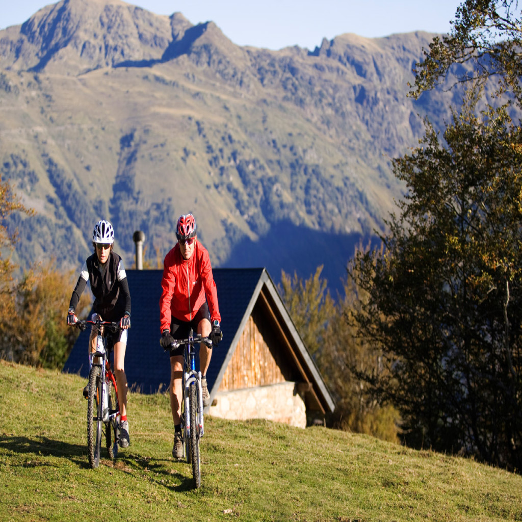
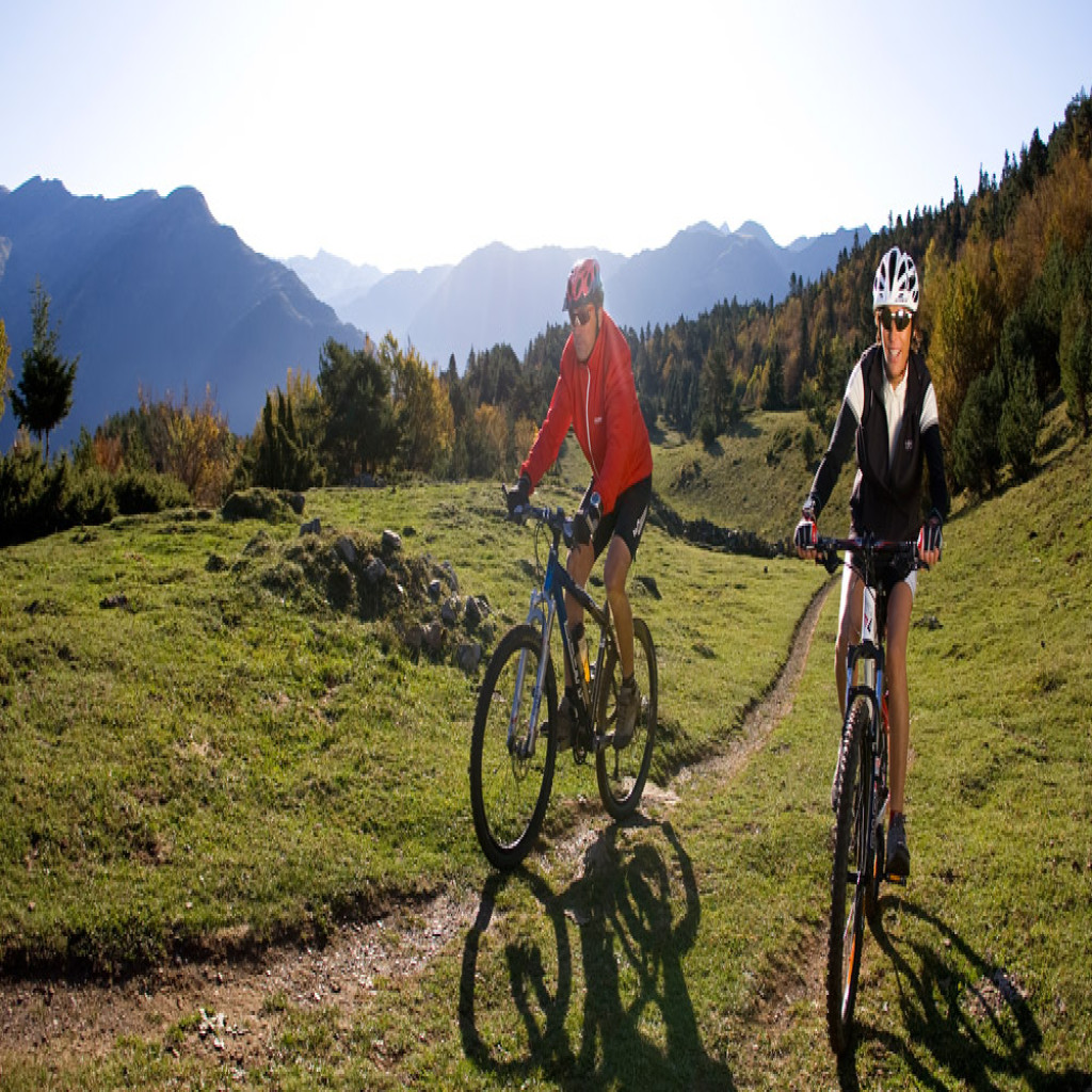
30 Route MTB

30
Baqueira | Tredòs | Salardú

Technical data
 Diffficulty: Easy
 Distance: 3.4 km
 Time: 30′
 Elevation: -250
 Spring, Summer and Autumn
 Asphalt: 0%, Earth 100%, Path 0%
Description
This is a linear and downhill trail that begins in Núcleo Baqueira 1500 and reaches Salardu, where you can connect with some of the easy trails surrounding the town. Much of the trail goes along the old Camin Reiau, running through the area.
Leaving the Baqueira 1500 car park, go to the back and head left until you find the road leading to Tredòs. It is a downhill forest track that crosses the Garonne and connects with Camin Reiau on the right. The track continues its downhill descent by the river side until reaching the highest point of Tredòs.
Cross the bridge and continue downhill alongside the river, until you find the Camin Reiau Salardu, which is paved on this stretch. You’ll arrive at Salardú by La Mola. Proceed to the tourist office by crossing at the roundabout and going up a short but steep climb.
It is interesting to spend a little time strolling through Tredòs’ streets and visiting the church of Cap d’Aran. Highlights in Salardú include the church of San Andreu, the Mola and the PyrenMuseu.
29 Route MTB

29
Plan de Beret | Orri | Plan de Beret
Technical data
 Diffficulty: Moderate
Distance: 8.8 km
Time: 1h 30′
Elevation: +200
 Summer
Asphalt: 11%, Earth 89%, Path 0%
Description
The trail is signposted only in the summer, which runs entirely through the Beret plain. It is exclusively signposted in the summer months by COPOS, which also offers a guide service.
Leaving the Beret cafeteria, cross the entire plain until reaching Orri, enjoying the views of the cattle and an old stretch of train track. In Orri, cross the road and keep going until you reach the source of the Garonne, with the water reservoir on the right. Go back onto the road until you get to the Orri car park and cross the Beret plain again, going back along the initial route.
Despite the fact that it is suitable for all levels and families with children, the short journey is transformed into a adventure by virtue of the uneven terrain of the Beret plains, with numerous culverts, turns, sidesteping of wetlands, and the crossing of small streams.
From Orri, you have to choice of ascending to the Maria Casteràs area of antennas, where the views over the Beret plain, Baqueira station and Garonne valley are unbeatable.
28 Route MTB
28
Vielha | Aubèrt | Es Bòrdes
Technical data
Diffficulty: Moderate
Distance: 10 km
Time: 1h 30′
Elevation: +300
 All year
Asphalt: 43%, Asphalt 57%, Path 0%
Description
This is a low difficulty linear trail that allows you to tour the Camin Reiau leaving from Vielha.
The trail starts at Betren, and heads to the sunny side of Vielha passing Palai de Geu. Once you reach Mijaran, carefully cross the N-230 and go down to the side of the river, passing the industrial facilities and continuing down the sidewalk to the trail that leads to the Vilac roundabout. Here you must cross the N-230 again and head along the road to Vilac for about 400 m. At the first bend, take the dirt track on the left to Betlan’s local road and go down it until you reach the N-230. From here, you’ll have to cycle about 300 m along the shoulder, with extreme caution of vehicles. Passing by Aubèrt, without going up to the village, leave the road and take the flat track to Bataller.
Camin Reiau begins about 200 m after crossing the Garonne. From here, you can enjoy this cool road full of history, which almost always has a smooth descent, until reaching Es Bordes.
You must be very cautious at intersections and stretches where you have to cycle on the road. You can leave your car in the village of Es Bordes or combine the return with public transport in the valley, which allows bicycles to be transported on the bus free of charge.
27 Route MTB
27
Betren | Escunhau | Betren
Technical data
Diffficulty: Moderate
Distance: 9.3 km
Time: 1h 50′
Elevation: +390
Spring, Summer and Autumn
Asphalt: 9%, Earth 91%, Path 0%
Description
This is a medium difficulty trail due to its slopes and, even though it passes through a stretch of track, it does not require too much technical preparation.
It passes through meadows and the lower region of the Tuca spruce forest. The views of this area of Arán are very pleasant.
Leaving Betren, go through the village along the main street and cross the C-28 road to take the trail that leads to Tuca. At kilometer 3.5, take the crossroads to the left and then the track that starts descending, which will quickly become a trail on the right. The arrival to the village of Escunhau, with its bell tower in the foreground, is quite spectacular. To finish the loop, go up on the right track and at km 6 you’ll reach the highest point of the trail, where you’ll start the descent to Betren and Vielha.
You can visit the village of Escunhau in the middle of the trail, which hides some very interesting surprises.
26 Route MTB
26
Vielha | Betren | Vielha
Technical data
Diffficulty: Easy
Distance: 2.8 km
Time: 20′
Elevation: +50
All year
Asphalt: 28%, Earth 55%, Path 18%
Description
This is an easy trail that runs between Vielha and Betren beside the river Garonne and gives you the opportunity to observe this riverside environment with its characteristic fauna and flora.
Leave Palai de Geu, head towards Betren, then take the riverside promenade bordering the Garonne. Pass under the bridge and go on top, then cross it. The building you’ll see next to the river is the old Metren grindstone, which is currently undergoing restoration and adaptation as a museum piece. After the bridge, half-way up the steep incline, take the path on the left which will bring you back to Vielha along a trail. The trail finishes by going along the sunny side of the quite streets and returning to the starting point beside the river Garonne. Keep in mind that you must respect the property in areas with private meadows and close any cattle gates you find.
The touristic and gastronomic offering in Vielha is very broad so it is advisable to approach the tourist office, where you will get the right advice. Once in Betren, you can finish your ascent of the village and visit the church of Sant Estèue.
25 Route MTB
25
Portilhon | Bòrdes de Sauvaga | Portilhon
Technical data
Diffficulty: Easy
Distance: 10.7 km
Time: 1h
Elevation: +80
Spring, Summer and Autumn
Asphalt: 0%, Earth 100%, Path 0%
Description
This is a linear route that runs from Cap del Portilhon, right on the border with France.
It is a quiet trail which can be done without rushing, while enjoying a wild natural setting with great views.
Take the forest track that runs from the same neck, riding on the flat and through the spruce forests of Samorera and Saubaga. Follow the track for about 5 km until it begins to drops down and reaches the edges of Sapòda. Once there, turn and go back on the track to the starting point.
Taking advantage of your stay in Portilhon to visit Aran Parc is a good choice.
24 Route MTB
24
Portilhon | Bosc d’Aubàs | Portilhon
Technical data
Diffficulty: Moderate
Distance: 6.8 km
Time: 45′
Elevation: +225
 Summer and Autumn
Asphalt: 0%, Earth 100%, Path 0%
Description
This is a linear trail that leaves from Cap del Portilhon. Go down the road about 300 meters, then take the track on the right with a slight incline.
The route is always done under the shade of the Aubàs spruce forest. The cool air, landscape and easy riding will ensure that you’ll enjoy a pleasant trip. About 500 meters from the junction, you’ll find the des Bruishes plain, a wetland area with glades that is well worth strolling through.
Before km 3.5, take the track on the left and in one hundred meters it will bring you to the Aubàs plain, with great views. The return will be an uphill route. Taking advantage of your stay in Portilhon to visit Aran Parc is a good choice.
23 Route MTB

23
Vielha | Pista de Tuca | Camin Sarrahèra | Pista Nere | Vielha
Technical data
 Diffficulty: Difficult
Distance: 13 km
Time: 2h 30′
Elevation: +560
Summer and Autumn
Asphalt: 19%, Earth 66%, Path 15%
Description
This route combines a gentle but prolonged ascent through the Tuca forest with a very interesting descent down the old Sarrahèra road, where you will have to use all your skills to avoid setting foot on the ground.
Leave Vielha and go to the village of Betren, then continue along the road until you reach the junction with the Tuca track, which you’ll take on the right. The ascent up this track is continuous, and you’ll pass the Costassa recreation area at km 2.5. Follow the main track until km 13, where you’ll take the track on the right that leads to the north of Vielha tunnel. The track peaks at 1525 m after which the descent begins. Take the trail on the left at km 8.3, where the most technical section of the trail begins. Be careful not to miss this junction, since the change in direction is very abrupt. You’ll then arrive at the track on the banks of the Nere, which will take you to the highest point of Vielha with its historic streets. Here you’ll find the dera Lan museum and factory, which may be visited, as well as a wide range of restaurants and shops throughout the town.
22 Route MTB

22
Bossòst | Margalida | Arres | Pònt deth Lop | Bossòst
Technical data
 Diffficulty: Very Difficult
Distance: 21.8 km
Time: 5h 30′
Elevation: +1000
Summer and Autumn
Asphalt: 8%, Earth 65%, Path 27%
Description
This is both a technically and physically difficult trail. The entire climb coincides with trail 5 just past the Arres reservoir.
The starting point of the route lies beside the Bossòst tourist information office, right next to the River Garonne. Cross the River Garonne and take the footpath towards Arres. At km 1.5, take the dirt track to Margalida and head across the entire valley until you reach the mines with the same name. Continue along the track and you’ll reach the Arres reservoir downhill, where the route by foot from the Victoria mines begins. This is highly recommended.
Follow the Victòria mine route and before entering the forest, take the left lane, which starts with a sharp descent. You’ll cross the track leading to the village of Arres de Sus. From here, you won’t find the GR 211 signposts until you reach Bossòst. Follow the wide lane to Arres de Jos where you will encounter quite a technical trail. It will take you from Arres de Jos to Pònt deth Lop, at the level of the Garonne. Without crossing the river, follow the track, which will quickly become a very technical trail until you reach Pont de Hèr. Take the Camin Reiau from here, which is mostly paved and flat until Bossòst.