21 Route MTB

21

Salardú | Prüedo | Arties | Salardú

Technical data

Diffficulty: Very Difficult

Distance: 32 km

Time: 4h 30′

Elevation: +800

Summer and Autumn

Asphalt: 43%, Earth 51%, Path 7%

Description

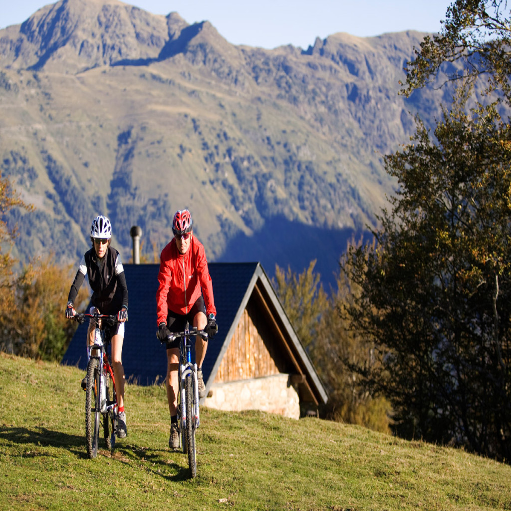
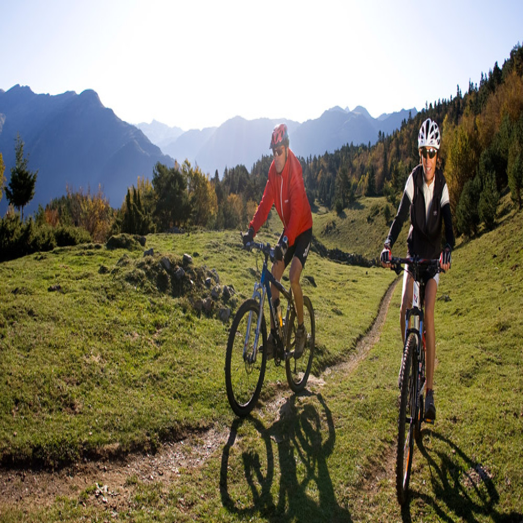
The natural surroundings are the highlight of this high mountain trail passing through the Bahns de Tredòs area and the upper Aiguamòg valley. It borders the Aigüestortes National Park and Estany de San Maurici.

Leave Salardú and go up the paved track to Banhs de Tredòs. The track, which is dirt here, continues to rise through a beautiful natural area and reaches the Pruedo plain (2050 m) surrounding Tuc dera Salana, which is on your left.

The descent to Valarties is quite fast, and on the valley floor you’ll find the paved road again that will take you to Arties. From there, you’ll just have to head towards Gessa and Unha on the GR 211 and go back to Salardú.

Los Banhs de Tredòs is a unique place (the highest hot springs in Europe), where you can enjoy this wonder of nature. From the Pruedo area, the views of Montardo and the Rius valley are the most spectacular you’ll see in Arán.

Finally, the trail passes through Arties, Gessa and Unha where you can take the opportunity to explore.

20 Route MTB

20

Beret | Montgarri | Beret

Technical data

Diffficulty: Moderate

Distance: 12.2 km

Time: 1h 45′

Elevation: +215

Summer and Autumn

Asphalt: 0%, Earth 100%, Path 0%

Description

The 12 km and 300 m height difference pass by quickly along this classic and busy trail. It is an ideal family route not to be missed, through which you can access one of Arán’s magical zones.

The trail is a loop and can be done in both directions, the terrain is signposted clockwise, with a descent on the left border of the Pallaresa. Leave Plan de Beret on the track to the left of the parking area, where a large metal building is located. The descent is pleasant, and you’ll alternate between sections of high mountain pastures and stretches of black pine forest. Pass by the Parrós river, where there a small shepherd’s hut and the Horcalh river.

From here, the descent is steeper until you reach the Montgarri chapel. Cross the river and continue along the dirt track to the main track, where you’ll turn right and begin the return to Pla de Beret.

A visit to Montgarri chapel, where you’ll find a mountain refuge, is a must. The natural surroundings between Plan de Beret and Montgarri are worth a stroll, with long stops for enjoying the landscape.

If you go with small children, it’s best to do the trail anti-clockwise, so even though you might have to walk due to the steep inclines back to Plan de Beret, you won’t have to climb the trail on the right, which vehicles travel on.

Keep in mind that it is a classic route, which is also for walking, so you have to be very careful and always yield the right-of-way to pedestrians.

19 Route MTB

19

Salardú | Tredòs | Pònt de Ruda | Tanau | Orri | Bagergue | Unha | Salardú

Technical data

Diffficulty: Difficult

Distance: 18.2 km

Time: 3h

Elevation: +700

Summer and Autumn

Asphalt: 22%, Earth 52%, Path 26%

Description

This is a physically tough route, since there is a 600 m height difference in just a few kilometres along narrow lanes, a track with steep inclines, and a stretch you might have to do by foot.

Leave Salardú and take the track that goes up to Aiguamòg; the paved track finishes at km 1.4 where there is a short descent to the lane from Tredòs, leading to terrain that is more uneven and sloping. Go past the crossing on your left, which would take you to the village of Baqueira 1500, and continue to km 4.7, where you’ll take the track that crosses the river and leads to the port road. Cross it and follow the steep ravine to Tanau. You’ll then link up to the track that rises to level 1800, continuing a few hundred metres down the Beret road. You’ll find the toughest inclines of the trail in this section.

You’ll get to Orri along a flat plane, and you’ll get to the source of the Garonne by the road, where the lane leading you to Bagergue and Unha down an impressive descent begins. Finally, you’ll reach Salardú via the local road.

A visit to the natural surroundings of Orri and Beret from a non-winter perspective is highly recommended. The views over Garonne valley with the Maladeta mountain as a backdrop are breathtaking.

18 Route MTB

18

Salardú | Ctera. Aiguamòg | Tredòs | Salardú

Technical data

Diffficulty: Easy

Distance: 3.8 km

Time: 45′

Elevation: +130

Spring, Summer and Autumn

Asfalto: 92%, Pista de tierra 8%, Sendero 0%

Description

An attractive trail for the whole family along which you’ll visit the village of Tredòs and enjoy fabulous views of Salardú and Unha.

The loop route on asphalt or concrete roads is very quiet, but you’ll have to watch out for cars on the Aiguamòg stretch of track on busy summer days.

From the Salardu tourist office, ride down to the roundabout, crossing with caution, and take the track to Aiguamòg. After climbing up a steep incline for a few hundred metres, take the road that will bring you to Tredòs. Cross the town on the side of the Garonne river and take the Camin Reiau, which will lead you, among crop fields, back to Salardú.

In Salardú, you’ll find La Mòla next to the river, which can be visited during the summer months and is a good place to rest up and for the kids to play.

17 Route MTB

17

Bagergue | Sta. Margalida | Bagergue

Technical data

Diffficulty: Easy

Distance: 3.1 km

Time: 30′

Elevation: +100

Spring, Summer and Autumn

Asfalt: 62%, Earth 38%, Path 0%

Description

This easy route allows you to take a tour around the village of Bagergue and discover all its charm. It is suitable for all levels. There is a more urban area through the streets of Bagergue and another one where you enter the Unhòla river valley.

Leave Bagergue via the highest point of the town, and at the junction with the Unhòla track, take the dirt road on the right. The slope is gentle prolonging to the Santa Margalida chapel. It is an ideal place for a short break and to enjoy the view of Lana de Bargergue and Poi d’Unha. A short and rapid descent leads you to the main paved road which you’ll take on the left and then head towards the village of Bagergue.

You can enjoy a good selection of restaurants in the village as well as visit the church of San Feliu, the Tarrau cheese factory and the Eth Corrau museum.

16 Route MTB

16

Salardú | Unha | Gessa | Salardú

Technical data

Diffficulty: Moderate

Distance: 3.4 km

Time: 35′

Elevation: +90

All year

Asphalt: 50%, Earth 50%, Path 0%

Description

The trail makes for an interesting visit to the villages of Salardú, Gessa and Unha, with their magnificent churches and fortified houses. If you ride off-trail through each village, you’ll discover some very authentic and well-preserved spots. There is also a wide range of restaurants and bars available for quick breaks along the trail.

Short steep inclines increase the trail’s level of difficulty to some extent.

Leave Salardú in the direction of Unha on the local road and cross the town. At the fountain at the exit of Unha, take the track to the right of the hill, heading towards Gessa via the highest point. From the town square, head back to Salardú via the local road. At the roundabout on the C-25 road, take the track on the left, which goes back to Unha. The return to Salardú is on the same trail, crossing through Unha. You can return from the roundabout to Salardú by following the C-25, which has a good shoulder despite heavy traffic. This will avoid a stretch of track with more slopes.

In Unha, don’t miss a visit to the Romanesque church of Santa Eulalia and the Nheu museum. In Salardú, visit the church of Sant Andreu and the PyrenMuseu.

15 Route MTB

15

Arties | Garòs | Arties

Technical data

Diffficulty: Easy

Distance: 5.8 km

Time: 45′

Elevation: +50

Spring, Summer and Autumn

Asphalt: 29%, Earth 71%, Path 0%

Description

A very quiet and easy trail that joins the loop between the villages of Arties and Garòs through little-used dirt tracks. Wander through its streets with your bike since it has plenty of charm and is worth the visit.

Leave Arties and cross the road at Sant Joan church, heading towards Garòs on the track that gradually slopes. When you arrive at Garòs, take Podaleres street at the town square, with a steep incline to the C-25 road. Cross the road and turn left towards Arties. The Banhs trail is very leafy and gives you an opportunity to enjoy the scenic riverside vegetation alongside the ancient thermal baths of Arties.

Make sure to visit the church of Santa Maria in Arties, a hallmark of Aranese Romanesque architecture, as well as the exhibitions held in the church of San Joan. A visit to the church of Sant Julian in Garòs is also very interesting.

14 Route MTB

14

Vielha | Casau | Pomèrola | Sarrahèra | Vielha

Datos técnicos

Diffficulty: Very Difficult

Distance: 24 km

Time: 5h 30′

Elevation: +930

Summer and Autumn

Asphalt: 10%, Earth 72%, Path 17%

Description

Long-distance loop leaving Vielha and offering spectacular views of both the upper part of Arán and the Port de Vielha. The trail between Gausac and Casau will be the first test to give you an idea of the difficulty of the route.

Leaving Vielha in the direction of Gausac, there are two steep slopes (only possible on foot) to access the upper part of the town and in particular the road to Casau. After leaving Casau, take a right onto the Santet track, which climbs up through a forest of pine and fir trees. At km 9.5, just at the end of the forest, take the track on the left that will lead you to the area around the Pomarola lodge, where a steep technical descent starts towards the banks of the Nere. To avoid the N-230 road, head back round to the top of the Nere river bank and return along the right-hand side. The Portet track will take you to the Sarrahèra path, at km 18.5, where a fast but non-technical descent will take you back to Vielha along the banks of the River Nere.

Careful at the top part of the Pomarola track, as you’ll have to watch out for the signposts to avoid getting lost. Nevertheless, it is recommended to have your GPS with you.

13 Routes MTB

13

Vielha | Vilac | Beusa | Gausac | Vielha

Technical data

Diffficulty: Moderate

Distance: 7.8 km

Time: 1h 20′

Elevation: +120

All Year

Asphalt: 60%, Earth 0%, Path 40%

Description

This is an easy route suitable for all levels of fitness, which leaving Vielha will take you around the flattest part of the area, following the course of the River Garonne.

The loop out to Vilac along the Santa Gemma trail is along footpaths, where at times you’ll have to dismount and walk up some short but steep slopes. Arriving at the Salient trail, take a left onto the footpath. Now you’ll start the descent towards to Vilac, ultimately passing below the village itself. If you feel like it, head up to the village and visit the Sant Fèlix church.

The route continues down the local road to Vilac, which you can do in one go if you want to avoid a short but fairly technical stretch. At the N-230 roundabout, take the side road up to the bridge over the River Garonne and the pathway just afterwards to the left. You can also take a short cut from the roundabout, climbing up to the right and crossing the Mijaran plain, which will take you to Vielha.

Be very careful when crossing the road at the N-230 roundabout, as there tends to be a lot of traffic.

12 Route MTB

12

Vielha | Pista Salient | Bords | Mont | Vilac | Vielha

Technical data

Diffficulty: Very Difficult

Distance: 38 km

Time: 6h

Elevation: +1200

Summer and Autumn

Asphalt: 14%, Earth 71%, Path 16%

Description

This is one of the most complete signposted routes at the Valle de Arán Mountain Bike Centre.

The climb to the Bordes de Salient is up the longest trail in Arán, with stunning views over Maladeta. Up to km 4.8 it coincides with Route 11, where you continue along the Salient trail until the end, a total of almost 20 km and a height difference of 1000 m. The descent from the Coret del Mont lodge, where the trail ends, back to the dirt track, is quite technical and calls for a great deal of orientation.

Despite the signposting, you should take an updated GPS as there is a fair stretch across mountain pastures, which in conditions of reduced visibility could hinder orientation. Once you come across the dirt track, continue downhill to the village of Mont. From here the track to Vielha coincides with Route 11, up to the N-230 road and back along the south-facing side to the village of Gausac and Vielha. The descent is very technical and will involve dismounting on certain stretches.

In the upper part of the Salient valley, the track levels out, and on days with good visibility the view over the central part of Arán and the Maladetas will remain engraved in your memory for a long time.